

 QuranGPT
The Cryosphere Sentinel: Trans-Himalayan Satellite Radar Grids and AI Early Warning Systems Deployed to Prevent Glacial Lake Outburst Floods
A comprehensive glaciology, earth observation, and climate disaster mitigation report on international space agencies deploying synthetic aperture radar (SAR) satellites, automated lake-level ultrasonic sensors, and AI early-warning telemetry to safeguard vulnerable Himalayan river valleys from catastrophic Glacial Lake Outburst Floods (GLOFs).
The Holy Quran Team
Author
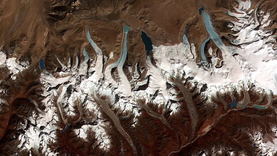
Across the towering mountain passes of the Hindu Kush Himalayas, the Karakoram, and the Tibetan Plateau—home to the greatest concentration of glacial ice outside the Earth's polar regions—international earth observation scientists, glaciologists, and national disaster agencies have officially activated the "Trans-Himalayan Cryosphere Early-Warning Network (THCEWN)".
The unified technological initiative—uniting the Indian Space Research Organisation (ISRO), NASA, the European Space Agency (ESA), and the International Centre for Integrated Mountain Development (ICIMOD)—deploys cutting-edge Synthetic Aperture Radar (SAR) satellites (including the joint NASA-ISRO NISAR constellation), high-frequency optical satellites, automated ultrasonic lake-level sensors, and edge-AI seismic vibration monitors to continuously track over 2,500 expanding high-altitude glacial lakes.
The deployment comes in the wake of accelerating Himalayan glacier retreat, where massive moraine dams holding back millions of cubic meters of frigid meltwater face heightened risks of catastrophic collapse—known scientifically as Glacial Lake Outburst Floods (GLOFs)—triggered by high-altitude rockslides, earthquakes, and sudden thermal spikes.
1. The Physics and Mechanics of Glacial Lake Outburst Floods (GLOFs)
Understanding how a tranquil high-altitude glacial lake transforms into a destructive wall of water requires analyzing cryospheric thermodynamics:
graph TD
    A["Rising High-Altitude Temperatures Accelerate Glacial Ice Mass Melting"] --> B["Meltwater Trapped Behind Unconsolidated Terminal Moraine Dams (Loose Rock & Permafrost)"]
    B --> C["Trigger Event: Hanging Ice Avalanche, Bedrock Landslide or High-Magnitude Earthquake"]
    C --> D["Massive Displacement Waves Over-Top & Liquefy Moraine Dam"]
    D --> E["Catastrophic GLOF: Millions of Cubic Meters of Water, Boulders & Mud Surge Down Gorge"]

    E --> F["SOLUTION: Multi-Layer Satellite Radar & Automated Solar Acoustic Warning Sirens"]
Key Technological Pillars of the Early-Warning Grid:
- NISAR Synthetic Aperture Radar (SAR) Telemetry: Utilizing L-band and S-band dual-frequency radar to penetrate thick monsoon cloud cover, measuring surface moraine dam displacement and slope instability down to millimeter-scale precision.
- Solar-Powered Ultrasonic Lake Sensors: Anchored at the perimeter of critical lakes (such as South Lhonak Lake in Sikkim and Imja Tsho in Nepal), transmitting real-time water elevation data via direct Iridium satellite transceivers.
- Downstream Automated Sirens and Cellular Broadcasts: If an anomalous 2-meter sudden lake level drop or sudden surge is detected, automated downstream sirens and emergency SMS cell-broadcasts are triggered within 90 seconds, providing downstream villagers with 30 to 90 minutes of crucial evacuation time.
2. High-Risk Himalayan Glacial Lakes Under Continuous Radar Surveillance
Glaciologists have categorized the most critical trans-Himalayan glacial lakes requiring 24/7 radar telemetry:
| Glacial Lake / Location | Elevation Above Sea Level | Estimated Water Volume | Downstream River Basin & Population at Risk |
|---|---|---|---|
| South Lhonak Lake (Sikkim, India) | 5,200 Meters | Over 65 Million $m^3$ | Teesta River Basin (Hydroelectric Dams & Towns). |
| Tsho Rolpa (Rolwaling, Nepal) | 4,580 Meters | Over 80 Million $m^3$ | Tama Koshi River Valley & Hydropower Corridors. |
| Imja Tsho (Everest Region, Nepal) | 5,010 Meters | Over 75 Million $m^3$ | Dudh Koshi River & Sherpa Village Settlements. |
| Raphstreng Tsho & Thorthormi (Bhutan) | 4,360 Meters | Over 110 Million $m^3$ | Punakha & Wangdue Phodrang Valleys. |
3. Controlled Siphoning and Engineering Mitigation
Beyond automated early warning, military and civil engineering teams are pioneering active risk reduction:
- Controlled Heavy-Duty Siphoning: Installing arrays of high-density polyethylene (HDPE) siphons to permanently lower water levels by 5 to 10 meters, drastically reducing hydraulic pressure on fragile moraine walls.
- Artificial Spillway Excavation: Utilizing specialized lightweight excavators airlifted by heavy-lift helicopters to carve reinforced concrete-lined overflow channels through terminal moraine crests.
4. Conclusion: Science and Cooperation at the Top of the World
The Trans-Himalayan Cryosphere Early-Warning Network represents a shining beacon of what international scientific collaboration can achieve in an era of accelerating climate change.
The glaciers of the Himalayas are the water towers of Asia, nourishing over 1.5 billion people downstream. By combining space-based satellite radars, artificial intelligence, and grassroots community preparedness, science is transforming from a passive observer of climate change into an active, life-saving guardian of mountain communities.